How will these resources help you?
The Geography of Disease is a popular unit at KS3, and feeds into many areas of specifications of GCSE and A-level. These resources bring a fresh perspective and have been carefully selected to avoid the many produced by health statisticians or medical professionals that are not suited to the teacher of Geography. For the specialist and non-specialist alike, these resources explain how disease touches multiple areas of geography, including the obvious spatial mapping, the impacts on globalisation, and how our interactions with the environment expose us to new pathogens for which we have no immunity. A focus throughout has been on giving the students the opportunity to review and analyse a wide range of geographical information, a key requirement at every level.
Geography 'returns'

Amid a Pandemic, Geography Returns With a Vengeance
by David Wolman, published by Wired, (2020)
This accessible article is an excellent starting point. Geography has appeared less significant in the age of the internet and rapid transport shrinking spaces. However, it has re-emerged alongside COVID, as we track infection, transmission, and vaccine development on local, regional, national, and global scales. Through lockdowns and social distancing, people’s space is restricted to the immediate of the local. The danger, first perceived as far off, creeps closer towards local and individual spaces. The article ends in a way that justifies our need to study the geography of disease: ‘It is naïve to think of other places as disconnected from our own geography, our own lives. Where matters – absolutely.’ Although many units on this topic are delivered at the end of KS3, students at GCSE and beyond will find the topic engaging, so this article serves as an excellent start to the unit, to justify reasons for 'the need to know'.
Mapping disease

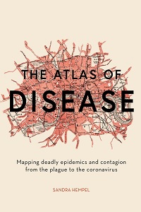
The Atlas of Disease: Mapping Deadly Epidemics and Contagion from the Plague to the Zika Virus
by Sandra Hempel, published by White Lion Publishing (Illustrated edition), (2018), 9781781317907
Written before the COVID 19 outbreak, this illustrated book shows how cartographic techniques have changed the way we respond to epidemics and pandemics. As its description states, the book interweaves new maps with contemporary illustrations. This is combined with an explanation of each disease, through its transmission, symptoms, prevalence, and treatment. While equally a history book, the maps are ideal for students to interpret a range of geographical information (a requirement of the KS3 National Curriculum) and to be critical of presentation techniques (required for GCSE Skill and Evaluation papers). This resource also demonstrates the increasing influence of globalisation as the speed of international transmission increases as we move through time.
COVID and globalisation

Corona's consequences - how the pandemic is changing globalization
by Hannes Vogel, published by DW Documentary, YouTube, (2021)
This documentary questions whether coronavirus is the beginning of the end of economic globalisation and is ideal for GCSE units on A Changing Economic World, and A-level units on Globalisation. It starts with Germany and the impact on its reliance on global supply chains, using TNCs such as Volkswagen as a case study. Internationally connected supply chains are not resilient if they are not complex enough. Diversification is needed with more suppliers spread more globally, and not relying on one region that can become inactive in the event of disease outbreak. This was evident by the outsourcing of medical mask-making to Asia, leading to supply disruptions, and showing how the virus has exposed globalisation as making the world’s economy and people vulnerable. Sixty per cent of Germans now see globalisation as a risk. We then move to Bangladesh, where textile factories were forced to close, leading to cancellation of orders and rising levels of poverty as people become unemployed. Finally, the growth of ‘slow fashion’ is examined, which does suggest the beginning of the end of globalisation.
COVID-19 Mapping

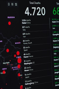
Mapping the Coronavirus Outbreak Across the World
published by Bloomberg UK, (updated daily)
This real-time resource provides a range of geographical information for students to analyse. Updated daily, it begins with the number of confirmed cases from the start of the COVID pandemic in a range of HICs and NEEs. There is an interactive choropleth map of deaths, followed by a graph familiar from government briefings during the pandemic of cases per day, globally and split into countries, again HICs and LICs. The resource concludes with a rolling average line graph of deaths and new cases. Brief commentary is provided, although the resource is of most value due to the raw data that it provides. Students can apply the basic AO1 and AO2 skills of describing the trends, as well as comparing regions and countries. They can hypothesise on the reasons for the trends (AO3) and undertake further research into geographical information such as development indicators, population pyramids and population density.
Audiovisual clip

Extinction: The Facts - How human impact on the environment is increasing the emergence of new diseases
published by BBC, (2020)
This clip explores the relation between human and animal interactions, and how this could lead to diseases.
Further materials
Global health in the 21st Century, published by Royal Geographical Society
Access this resource
Deforestation is leading to more infectious diseases in humans by Katarina Zimmer, published by National Geographic, (2019)
Read this article
How does Disease Move? Crash Course Geography #34 by Crash Course, published by YouTube, (2021)
Watch this video
David Newell is Head of Geography at Millais School in Horsham, West Sussex. He has held the GA’s Secondary Geography Quality Mark since 2015, and has worked as a Specialist Leader in Education, advising schools on improving their Geography provision.
Text © David Newell, 2022.
Text © David Newell, 2022.


